
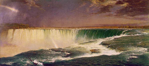
THE CATARACTS
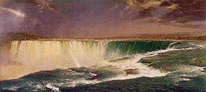
Niagara
Frederick Edwin Church
1857
oil on canvas
42¼" x 90½"
the Corcoran Gallery of Art
To stand
beside the Falls of Niagara and to hear the incessant roaring thunder and to feel the
earth moving to the vibration of the sheer volume of water is to understand the grandeur
and dynamism of Niagara Falls.
Niagara originates from the
Neutral Indian name "Ongniaahra"
meaning
"Thunder of Waters"
Niagara
Falls is the third greatest waterfalls in the world in terms of volume of water
Boyoma [Stanley] Falls - Congo - 17,000 m3/sec
Khone Falls - Laos - 11,610 m3/sec
Horseshoe Falls - Niagara Falls - 5,830m3/sec
INDEX
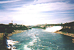
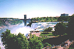
The
Niagara River
The
Niagara Gorge
The Horseshoe Falls
The American Falls
The Illumination Lights
The Whirlpool
Oddities
THE
NIAGARA RIVER
The Niagara River has
been cutting its way across the shelf of the rock between Lake Ontario and Lake Erie for
about 12,000 years.
It seems a long time in
terms of the human experience, but compared to the 500 million year old rocks of the
Niagara Escarpment, Niagara Falls was born yesterday.
If we consider the
Niagara Escarpment to be 1 Day Old, the Niagara River as we know it has only been in
existence for 4 Seconds.
The
Upper Niagara River Cascades
The Niagara River is 12,000 years old
The Niagara River is 35 miles (59 km)
long and runs in a south to north direction from Lake Erie to Lake Ontario.
The Niagara River is a narrow passage
of water joining two larger bodies of water and is actually a "strait".
A river is an outlet for a drainage
area ordinarily called the river basin. Tributaries flow towards it and it is the means by
which the whole region between water-sheds is drained. The Niagara River is not like this.
It is not located between water-sheds and drains no large area. It receives no rivers of
importance. For this reason it may be properly called a strait connecting two inland
bodies of water.
The Great Lakes system is considered to
be the area drained by the Niagara River. The area of the upper Great Lakes is 684,000
square kilometers (264,000 square miles).
Wind is the most important regulator of
the Niagara River. Wind controls the water level and speed of the water. Southwest winds
over Lake Erie increase the speed and the water level of the Niagara River. East winds
across Lake Erie in contrast reduces the water speed and water level of the Niagara River.
The elevation difference between Lake
Erie and Lake Ontario is 326 feet (99m).
The Niagara River has four distinct
sections:
1) the Upper Niagara River
2) the Cascades and the Falls
3) the American Goat Island Channel
4) the Lower Niagara River
THE UPPER NIAGARA RIVER:
The upper Niagara River extends 35
kilometers (22 miles) from Lake Erie downstream to the Cascade Rapids. The Cascade Rapids
begins 1 kilometer (0.6 miles) upstream of the Horseshoe Falls. Niagara Falls.
The maximum width of the Niagara River
is 2580 meters (8500 feet) at Buffalo/Fort Erie. The river width narrows to approximately
460 meters (1500 feet) at Squaw Island located below the Peace Bridge. Water flowing
past the Peace Bridge can attain a speed of 8.18 miles per hour.
Downstream of Squaw Island, the river
widens to approximately 610 meters (2000 feet) at a speed of 3.4 miles per hour.
From Lake Erie to Strawberry Island
which is located 8 kilometers (5 miles) downstream of Lake Erie, the river elevation
drops six (6) feet.
At Grand Island, the river divides into
the west channel (known as the Chippawa Channel) and the east channel (known as the
American or Tonawanda Channel).
Grand Island, located upstream from the
Horseshoe Falls, has an area of 70 square kilometers (27 square miles). It is the largest
of the islands along the Niagara River.
The Chippawa Channel is approximately
17.7 kilometers (11 miles) in length and varies in width from 460 meters (2000 feet) to
1220 meters (4000 feet). Velocity of the water flow is averages 2 miles per hour. This
Chippawa Channel carries 60% of the total river flow.
The Tonawanda Channel is 24 kilometers
(15 miles) in length and varies in width from 460 meters (1500 feet) to 610 meters (2000
feet) in width. Velocity of the water flow averages 2 miles per hour.
At the north end of Grand Island, both
the Chippawa and Tonawanda Channels merge to form the 4.8 kilometer (3 mile long) Chippawa
- Grass Island Pool. The long term elevation of this pool is 171.16 meters (561.55 feet)
above sea level. At the downstream end of the Chippawa - Grass Island Pool is
the International Niagara Control Dam.
The International Niagara Control Dam
is located approximately 1370 meters (4500 feet) upstream of the Horseshoe Falls. It has
eighteen (18) control gates which are lifted or lowered in order to control the amount of
water that flows over the Falls and to regulate the water level in the Chippawa - Grass
Island Pool for hydro diversion. The water velocity is 4.4 to 4.8 feet per
second (3.2 miles per hour/5.2 kilometers per hour).
Water is diverted from the Chippawa -
Grass Island Pool for hydro-electric power generation. Approximately 123,490 - 162,000
cubic feet of water per second is diverted. This water feeds the following hydro-electric
generating stations:
1. Sir Adam Beck Power Generating
Station #1 & #2
2. Niagara Power Generating Station (Robert Moses)
3. Canadian Niagara Generating Station (Rankine Plant)
The water diverted for the Sir Adam
Beck and Robert Moses power stations is returned to the Niagara River at Queenston -
Lewiston.
The water diverted for the Canadian
Niagara Generating Station is returned to the Maid of the Mist plunge pool at the base of
the Horseshoe Falls.
From Lake Erie to the Chippawa - Grass
Island Pool the river bed drops 2.7 meters (9 feet) in elevation.
The maximum depth of the upper Niagara
River is 12 meters (41 feet) at the International Railroad Bridge in Buffalo/Fort Erie.
There are eight major islands in
the Upper Niagara River. They are: (in order from Lake Erie to Niagara
Falls)
1) Squaw Island (American)
2) Strawberry Island (American)
3) Beaver Island (American) - 40 acres
4) Grand Island (American) - 17,381 acres
5) Tonawanda Island (American)
6) Buckhorn Island (American) - 146 acres
7) Navy Island (Canadian) - 316 acres
8) Goat Island (American) - 70 acres
THE CASCADES AND THE FALLS:
Downstream of the International Niagara
Control Dam, the river descends 15 meters (50 feet) through a series of rapids and
cascades. The Cascade area is divided into two channels by Goat Island. These channels
carry the flow of the water to both the Horseshoe Falls and the American Falls.
The water level located upstream of
Niagara Falls is 561 feet (171m) above sea level.
The average depth of the Niagara River
upstream of Niagara Falls is 15 feet (4.5m).The deepest area of the Niagara River upstream
of Niagara Falls is approximately 27 feet (8m).
Since the International Control Dam was
built, the cascades or rapids located just upstream from the Falls is on average just 2
feet (0.6m) to 3 feet (0.9m) in depth
The rock strata located upstream of the
Horseshoe Falls tilts 20 feet (6m) towards the Canadian shoreline in 1 mile (1.6 km).
From eastern end of Goat Island to the
crest of the Horseshoe Falls there is an elevation drop of 55 feet (16m) forming a series
of rapids.
The rate of water flow over the Falls
prior to hydro diversion was in excess of 220,000 cubic feet per second. Current flow
rates of water over the Falls are as follows:
April 1st - September 15th (8 am
to 10 pm) = minimum 100,000 cf/s
September 6th - October 31st (8
am to 8 pm) = minimum 100,000cf/s
All Other Times =
minimum 50,000 cf/s
cf/s = cubic feet per second
Ninety percent (90%) of the total
amount of water flows over the Horseshoe Falls while ten percent (10%) of the total amount
of the water flows over the American Falls.
Thirty-seven million (37,000,000)
gallons of water per minute are flowing over the Falls when the rate of flow is 100,000
cubic feet per second.
The long term average water flow of the
Niagara River is 205,000 cubic feet per second. The daily rate of water flow is subject to
vary from day to day.
Each day, approximately 164,000 cubic
feet of water per second is diverted upstream of the Falls for hydro-electric
power generation.
Since the early 1900's, water diversion
for hydro-electric generation has reduced the volume of water flowing over the Falls. This
diversion has caused the plunge pool at the base of the Falls to drop by approximately 15
feet (4.6 meters), and in turn increasing the height of the Falls by the same amount.
THE AMERICAN GOAT ISLAND CHANNEL:
The American Channel is created by Goat
Island which divides the flow of the Niagara River. Only 10% of the total river flow
follows this channel. It is 3,000 feet (914m) long, extending from the eastern tip of Goat island
to the American Falls. It is located between Goat Island and the American mainland. The
width of the channel at the eastern tip of Goat Island is approximately 800 feet
(244m). At the
American Falls, the channel widens to approximately 1,100 feet (335m). The upper rapids are
created by an approximate 60 feet (18m) descent in the river bed over this short distance. The
American Channel has many small islands which are scattered along its course. The names
of these islands are:
Bird Island
Brig Island
Chapin Island
Crow Island
Green Island (formerly Bath Island)
Luna Island
Robinson Island
Ship Island
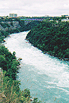
THE LOWER NIAGARA RIVER:
The Niagara Gorge extends from the
Horseshoe Falls for 11 kilometers (7 miles) downstream to the beginning of the Niagara
Escarpment at Queenston - Lewiston.
The Niagara Gorge has five identifiable
sections: (in order from most current to earliest)
1) Upper Great Gorge
2) Whirlpool Rapids Gorge
3) Lower Great Gorge
4) Old Narrow Gorge
5) Lewiston Branch Gorge
The average river flow at Queenston
between 1860 - 1998 was 207,760 cubic feet of water per second.
The minimum width of the Niagara River
is 76 meters (250 feet) at the Niagara Glen.
The width of the Niagara River at
Niagara On the Lake is 915 meters (3000 feet).
The depth of the Niagara River
downstream of the Falls varies from place to place as follows:
at the base of the Horseshoe
Falls - 56 meters (184 Feet)
at the Whirlpool Bridge - 65
meters (215 feet)
at the Whirlpool - 38 meters (126
feet)
at Queenston - Lewiston - 30
meters (100 feet)
Each day it is estimated that the
Niagara River carries over 80,000 tons of dissolved minerals and sediments towards Lake
Ontario. It is equivalent to 1,600 railway freight car loads.
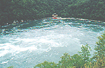
The Whirlpool is a basin which is 518
meters (1700 feet) long and 365 meters (1200 feet) wide.
To learn more about the Falls of
Niagara visit the
Origins of Niagara
Falls section.
THE NIAGARA
GORGE
FOR THE PAST 12,000 YEARS THE
HYDRODYNAMIC FORCES OF NATURE HAVE BEEN CREATING A MAJESTIC ART WORK CALLED
THE NIAGARA RIVER
AND
FALLS OF NIAGARA
The Niagara River Gorge which
commences at its place of birth in Queenston - Lewiston has eroded approximately 7 miles
(11 km) upstream to the site of the Horseshoe Falls.
The river water did not cause the
gorge to be as wide as it is today. Most widening has been caused by erosion and
weathering resulting in rock falls.
There are five (5) identifiable sections of the
Niagara Gorge. They are:
UPPER
GREAT GORGE is the section located
nearest the Falls. It has an average width of 365.5 meters (1,200 feet). The
Niagara River from the base of the Horseshoe Falls descends only 1.5 meters (5 feet) to
the upper reaches of the Whirlpool Rapids. This section of the river is known as the Maid
of the Mist Pool is navigable for the most of its entire length. It is this section which
the Maid of the Mist Tour Boats ply their services. is the section located
nearest the Falls. It has an average width of 365.5 meters (1,200 feet). The
Niagara River from the base of the Horseshoe Falls descends only 1.5 meters (5 feet) to
the upper reaches of the Whirlpool Rapids. This section of the river is known as the Maid
of the Mist Pool is navigable for the most of its entire length. It is this section which
the Maid of the Mist Tour Boats ply their services.
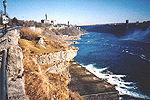
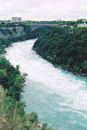
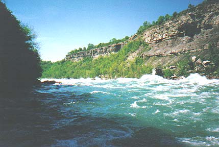
A view
of the Upper Great Gorge
WHIRLPOOL
RAPIDS GORGE is the section located
north of the Whirlpool International Bridge and the south of the Whirlpool. It has
an average width of 228.5 meters (750 feet wide). This portion of the gorge is world
famous for its rapids. The width of the Whirlpool Rapids Gorge narrows to
approximately 150 yards (137m). The rapids generated here are amongst the wildest and most
formidable in the world (class V-VI).
The depth of the Whirlpool Rapids is
10.7 meters (35 feet) and the speed of the water at the Whirlpool Rapids is 35.4
kilometers/hr
(22 mph). The speed is the result of the narrow width of the gorge as well as the rapid
descent of the river. The descent is 15.8 meters (52 feet) in less than 1.6 kilometers
(1.2 miles). Water in the Whirlpool Rapids flow towards the American shoreline causing
extensive erosion.
Since the early 1950's, because of
water diversion for hydro generation, the water level of the Whirlpool Rapids has dropped
12 - 25 feet (4-8m). Today less than fifty (<50%) percent of the original maximum amount water
flows through this portion of the river.
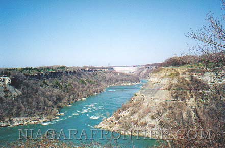
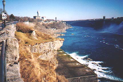
A view
of the Whirlpool Rapids & Gorge looking South from the Whirlpool
LOWER GREAT GORGE
(DEVIL'S HOLE) is the section located just north
of the Whirlpool. Approximately 7,000 years ago this part of the gorge was the site
of twin falls in the area of the
Niagara
Glen before becoming a single waterfall once again as the waters of Lake
Erie began drainage through the Niagara River system. Here, the Niagara Gorge is only 250
feet (76m) wide. The Lower Rapids (Devil's Hole Rapids) are located here. The rapid descent
of the river - 14 meters (47 feet) in less than one third of a mile contribute to a white
water rapids (class III). A portion of this section of rapids is called the "Devil's
Hole" for its sudden elevation drop of 16 feet (5m).
A view
of the Lower Great Gorge looking North from the Whirlpool towards the Old Narrow Gorge and
the Hydro Generating Stations
OLD
NARROW GORGE is the section located
near the Hydro Generating Stations just South of Queenston - Lewiston. It is
the birth site of Niagara Falls and the Niagara Gorge 12,000 years ago. This portion of
the river is navigable but the strong current and Hydro Generating Stations create
inherent hazards.
A view
of the Old Narrow Gorge looking North towards the birthplace of Niagara Falls
LEWISTON
BRANCH GORGE is the section which
extends from Queenston - Lewiston northward to Lake Ontario. The elevation drop from the
end of the Lower Rapids (Devil's Hole Rapids) to Lake Ontario is approximately 1.5 meter
(5 feet). This section is navigable.
A view
of the Niagara River along the Lewiston Branch Gorge looking South towards the Niagara
Escarpment
at Queenston - Lewiston
The shape of each section of the
Niagara Gorge has been molded from the differing amounts of water that once flowed at
variable speeds during the retreat of the last ice age and from erosion.
The depth of the gorge is variable up
to 300 feet (91m) in depth (including water depth).
A view
of the Whirlpool Rapids from the Great Gorge Adventure Boardwalk
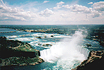
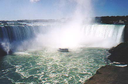
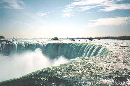
THE HORSESHOE
FALLS

The
Horseshoe Falls
The crest line of Niagara Falls was not
described as horseshoe shaped until 1721.
The Horseshoe Falls, commonly
referred to as "the Canadian Falls" is not located entirely in Canada. At the
present time based upon data from the International Boundary Commission, about
350-400 feet (107m-122m) of the Horseshoe Falls crest line extending from the
shoreline of Goat Island lies in American territory. As time goes on and erosion
continues, the crest line will continue to be extended within the American
border.
The speed of the Niagara River at
the crest of the Horseshoe Falls is along the flanks is 8 miles (12.8km/h) per hour at a flow rate of
100,000 cubic feet per second. The speed of the water at the apex (centre) is
13.6 miles per hour (22km/h) at a flow rate of 100,000 cubic feet per second.
The height of the Horseshoe Falls
is 53 meters (173 feet) to the plunge pool at the base of the Falls.
The crest line of the Horseshoe Falls
is 2,200 feet (670m) in width. The crest line of the Horseshoe Falls is 500 feet (152
meters) above sea level.
The water depth at the base of the
Horseshoe Falls is 184 feet (56m).
Behind the Horseshoe Falls is a rock
shelf approximately 20 feet (6m) in width, however because of the sheer shale cliffs on
either side and because of the volume of water falling, access is not possible.
Between 8:00 a.m. and 9:00 p.m. each
day, the volume of water flowing over the Falls is at its maximum rate.
In one second, a total of 600,000
gallons of water flows over the width of the crest line of the Horseshoe Falls.
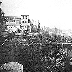
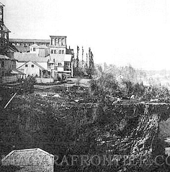
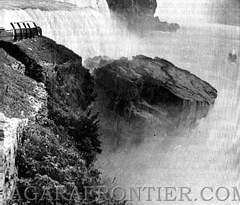
An
historical view of the Table Rock circa 1862 in Queen Victoria Park
The depth of the Niagara River just
north of the Horseshoe Falls is 56.6 meters (185 feet) deep, however rock talus fills in a
portion of the bottom to within 22 meters (72 feet) of the surface.
Prior to Hydro water diversion
beginning in 1956 and 1962, the depth of the water in at the apex (center) of the crest
line of the Horseshoe Falls was 10 feet (3m). Currently this depth averages 2-3
feet (1m).
The Scenic Tunnels located in the Table
Rock Complex at the brink of the Horseshoe Falls will take visitors down an elevator
approximately 170 feet (51.8m) to two tunnels leading to the base of the Falls. One tunnel
is 150 feet long (46m) and leads to an outdoor observation deck to the north side of the
Horseshoe Falls. A second 240 foot (73m) tunnel leads to a portal view behind the
Horseshoe Falls. Each tunnel is 7 feet (2m) in height and 4.5 feet (1.4m) wide. The
tunnels were built in 1888 and for many years were known as "the Cave of the Forty
Thieves".
In January 1818 at 9 p.m. a large
section of rock measuring 160 feet (49m) by 30 feet (9m) broke away from the Horseshoe Falls.
Near midnight on March 29th 1848,
Niagara Falls ran dry. A South-West gale blowing off of Lake Erie caused ice to jamb and
dam up at the mouth of the Niagara River causing the water flow over the Horseshoe Falls
and American Falls to be reduced to a trickle. The water flow was not returned until
approximately forty hours later, when a wind shift broke apart the ice jam. On March
31st 1848, the river flow returned to its normal rate.
On January 19th 1887, a section of rock
measuring 160 feet (49m) by 60 feet (9m) collapsed from the Table Rock into the gorge below. This was
the collapse of the original Table Rock.
The most dramatic change to the
Horseshoe Falls occurred on January 10th 1889. A gale force wind caused much more water
than usual to be forced over the crest line of the Horseshoe Falls. This extra weight
caused a large section of rock to fall from the apex (center) of the horseshoe. The depth
of the water flowing over the flanks of the crest line immediately dropped 15 inches as
the water began flowing towards the fractured center.
On January 8th 1891 at
approximately 9 p.m., a large mass of rock again fell from the apex of the Horseshoe Falls
changing the shape of the crest line from an angle at the apex to a horseshoe shape.
In 1953 - 1954, a series of coffer dams
were built around the Horseshoe Falls stopping the water flow over the crest to enable
remedial work to be carried out once the crest line dried out. Twenty-four thousand cubic
yards of rock were excavated from the flank of Goat Island. Sixty-four thousand cubic
yards of rock was excavated from flank of the Table Rock.
Substantial rock falls occurred at
Table Rock in 1828, 1829, 1850, 1862, 1887, 1889 and 1891. In 1935, the remainder of Table
Rock which posed a safety hazard was blasted away.
the original Table Rock
as it exists today
(the Table Rock was
approximately 200 feet (61m) long with a 60 foot (18m) overhang)
Goat Island separates the Horseshoe
Falls from the American Falls.
TERRAPIN TOWER
In the 1820's, Peter and Augustus
Porter were owners of the American Falls and all their surrounding lands including Goat
Island. As a tourist attraction, they built a wooden pier extending 300 yards from Goat
Island to a series of half submerged rocks known as the "Terrapin Rocks". It is
these turtle shaped rocks which led to the current name of Terrapin Point.
In 1833, the Porter brothers built a 45
foot (14m) tall tower structure with an observation deck at the end of this pier. This tower
stood for approximately 50 years before erosion rendered the structure uninhabitable. It
was subsequently demolished.
The Terrapin Tower was built on the
precipice of the Horseshoe Falls at Terrapin Point in 1833.
The structure was 45 feet (14m) tall and 12 feet (4m) in diameter. It was described as rude circular
structure built from stones found in the vicinity.
Inside the tower, was a winding stairway that was ascended by many thousands of visitors
from every part of the world over a 40 year period from 1833 to 1873. A small
balcony at the top of this tower provided visitors with a spectacular view of the Falls
and the gorge below.
In 1873, the tower was blown up with gun powder not because it was dangerous but because
it might prove to be an attraction contrary to the interests of a company that had
purchased land adjacent to Prospect Park.
In many historical photographs,
drawings and paintings, Terrapin Tower can be seen located along the crest line of the
Horseshoe Falls nearest Goat Island.
In 1955, the area of the Terrapin Rocks
was drained and back filled to create an artificial viewing area while smoothing the flow
of water over the Goat Island flank of the crest line. Today tourists view the Horseshoe
Falls from this area.
To learn more about Terrapin Tower, visit the
History of Towers
section.
In 1969, a major crack was discovered
in the rock formation at Terrapin Point. For safety, this observation area was closed to
members of the public until 1983 when 25,000 tons of unstable rock was blasted away by
members of the U.S. Army Corps of Engineers.
Rainbows can be seen at the Falls in
the early morning as the sun rises and in the late afternoon as the sun begins to set. The
sun at these times reflects the water from the rising mist.

A view
of the Crestline of the Horseshoe Falls from the Table Rock observation area
To learn more about the Falls of
Niagara visit the
Origins of Niagara
Falls section.
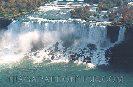
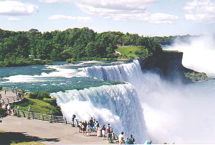
THE
AMERICAN FALLS
THE AMERICAN FALLS (Rainbow Falls)
&
THE LUNA FALLS (Bridal Veil Falls)

The
American Falls & Bridal Veil Falls
The American Falls is also known as the
Rainbow Falls.
The Luna Falls is also known as the
Bridal Veil Falls or Iris Falls.
One hundred (100%) percent of the
Bridal Veil Falls/Luna Falls and the American Falls are located in the U.S.A.

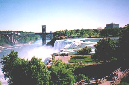
The
American Falls from Prospect Point
The Bridal Veil Falls and the American
Falls has a total crest line of 1,100 feet (326m) in width and has a height of 182 feet
(56 meters).
The height of the American Falls is
182 feet (56m) from the crest line to the river level. This height is deceptive when considering
the massive amount of rock talus at its base.
The talus (broken rock ) at the
base of the Bridal Veil Falls and the American Falls reduces the uninterrupted fall of the
water to as little as 70 feet (21m).
The crest line of the Bridal Veil
Falls/Luna Falls is 56 feet (17 meters) in width. It is located immediately south of
the much larger American Falls but separated from the main waterfalls by a thin strip of
land known as Luna Island. The crest line of Bridal Veil Falls is 508 feet (155 meters)
above sea level.
The crest line of the American Falls
(Rainbow Falls) is approximately 950 feet (290 meters) in width. The depth of the water at
the crest is approximately 2 feet (0.6 meters). The crest line of the American Falls is
510 feet (155 meters) above sea level. The speed of the river flow at the crest
of the American Falls is 6.8 feet per second (4.6 miles per hour/ 7.4 kilometers
per hour) when the flow is at 100,000 cubic feet per second.
In one second, a total of 150,000
gallons of water flows over the width of the crest line of the American Falls.
The Bridal Veil/Luna Falls is the site
of "The Cave Of The Winds" tourist attraction. A guide takes tourists to the
base of the Niagara Gorge and onto a series of wooden decks below the Falls. The closest
deck is known as the hurricane deck and is located only twenty-five feet away from the
cascading water falls. The hurricane deck is named because of the wind and water being
generated by the Bridal Veil/Luna Falls.
CAVE OF THE WINDS
The original "Cave of the
Winds" was a real cavern located behind the Bridal Veil Falls. It measured
approximately 130 feet (40m) high, 100 feet (30m) wide and 30 feet (9m) in depth. During the early 1900's
there was a pathway that tourists could take to the cave which was located behind the
Falls. It was quite the popular spot. The Cave of the Winds was first called "Aeolus'
Cave" after the fabled Greek God of Winds. Unfortunately what forces of nature had
created over thousands of years was also responsible for its demise through water erosion.
In 1954, one of the greatest rock falls occurred at Prospect Point. This rock fall had
altered the appearance of the Cave of the Winds forever. Coupled with smaller but similar
rock falls at Terrapin Point, the entrance to the cave became too dangerous for tourists.
The overhanging ledge of dolostone which protected tourists entering the Cave of the Winds
from the water of the Falls was in serious danger of collapsing. As a result, the original
Cave of the Winds was destroyed by a controlled dynamite blast in 1955.
An observation tower is located at
Prospect Point just north of the American Falls. At approximately two hundred and eighty
(280) feet (85m) in height from the base of the gorge, this tower provides an excellent viewing
platform and also houses an elevator that transports tourists to the Maid of the Mist dock
below. In 1998, the State of New York announced that this tower would be replaced in the
near future for a structure more adapted to the scenic beauty of the Falls.
The American Falls (Rainbow Falls) is
most famous for rainbows. Rainbows quite often appear in the morning as the sun rises in
the eastern horizon and shines through the veil of mist generated from the falling water.

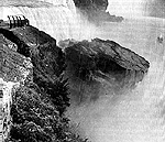
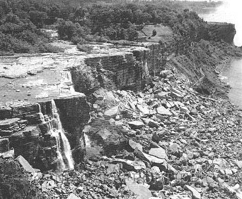
a photograph of the
de-watered American Falls in 1969
In 1969, the United States Army Corps
of Engineers (USACE) carried out a study of the rock formation at the crest of the
American Falls. A cofferdam was constructed of rock and fill extending from the mainland
to the head of Goat Island, cutting off the flow of water to the American Falls. The dam
was completed and the water flow of the Falls were shut off on July 12th 1969 and remained
that way while inspections were carried out. The coffer dam was removed beginning on
November 25th 1969, and by midnight of November 26th 1969 the full water flow over the
American Falls were restored. In 1974, the seven year study and deliberation came to an
end. Several possibilities were recommended to alter to state of the cosmetic appearance
of the American Falls. One proposed the removal of the rock talus from the base of the
Falls while one proposal suggested let nature and erosion take its course. The Falls were
left to the forces of nature through erosion.
Currently, the rate of water flow over
the American Falls is insufficient for the natural erosion of the rock talus at the base.
During the late winter of 1931, a rock
fall occurred at the crest of the American Falls. It is estimated that 76,000 tons of rock
fell into the gorge.
On July 28th 1954 at 4:05 p.m., a large
rock fall took place at Prospect Point ( a famous landmark from which tourists viewed the
Falls) just north of the American Falls. An estimated 185,000 tons of rock plunged to the
base of the gorge.
An
historical photograph of the 1954 rock fall at Prospect Point
Luna Island separates the Bridal Veil
Falls/Luna Falls from the American Falls. It is approximately 50 meters (164
feet) in length and 97
feet (30 meters) wide.
Luna is a Latin word for
"moon" and refers to the coloured Lunar Bow (as in rainbow).
FRANCIS ABBOTT
the Hermit of Niagara
Francis Abbott was known as the Hermit
of Niagara. Abbott arrived at Niagara Falls in June of 1829. He began living in the forest
on Goat Island. The island had only one small log cabin that had been previously erected
an occupied by a pioneer family before the island was purchased by Peter and Augustus
Porter. The cabin had since been abandoned. Abbott had asked the Porter's for permission
to live on Goat Island but this request was denied. Despite this lack of permission,
Abbott took up residence in the cabin. For the next two years, Abbott was the sole
resident of Goat Island. He became a part of folklore with his daily activities among the
tourists. Quite often, Abbott would entertain the tourists by performing balancing acts on
the wooden pier leading to Terrapin Tower. Abbott died by drowning on June 10th 1831. At
approximately 2 p.m., Abbott was witnessed by a passing ferryman to enter the water below
the American Falls after neatly folding his clothes on shore. It appeared that Abbott was
bathing. The ferryman saw Abbott go under the water surface and not come back
up. A
search for Abbott that day continued for several hours without success.
On June 21st, 1831, the body of Francis
Abbott was recovered from the Niagara River near Fort Niagara eleven days after he
disappeared. The original headstone is unreadable now. It was knocked over at some point
and was neglected. It read:
Francis Abbott, the Hermit of Niagara
Died June 10, 1831
He died in his 28th year
It is unknown whether his death was
suicide or accident.
Found chiseled into a rock on Luna
Island possibly by Abbott was the inscription:
"All is Change,
Eternal Progress, No Death".
A view
of the American Falls & Luna Island
To learn more about the Falls of
Niagara visit the
Origins of Niagara
Falls section.
THE
WHIRLPOOL
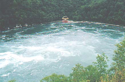
The
Niagara River Whirlpool
The Whirlpool is a natural phenomenon
created approximately six thousand years ago by the combination of the immense flow of the
Niagara River and erosion which resulted in the course of the river making a dog leg turn
in direction. As the Falls eroded, it came upon a buried gorge which had been filled in
with glacial silt and debris. This buried gorge followed a path perpendicular to the
receding Falls. As a result, the path of the Falls took the course of least resistance
and began following the path of the ancient glacial buried gorge.
It is a large circular pool of water
located 5.3 km (3.2 miles) downstream of the Falls. The water at this point makes a right
ninety degree turn in its course. The restricted width of the narrow gorge creates a rate
of flow equal to the great rapids of the world.
When the water flow is at its greatest
during the daytime, the water flow actually pushes straight past the actual turn and
enters the whirlpool where the water follows the contour of the circular edge of the
whirlpool and loops counter clockwise back to near where it entered the whirlpool. At this
point, the exit flow of the water passes underneath (underpass) and intersects the water
entering the whirlpool as it exits north towards Queenston and on to Lake Ontario.
Between 9:00 p.m. and 8:00 a.m. each
and every day, the Sir Adam Beck and Robert Moses Hydro Generating Stations begin drawing
their maximum allowed water diversion reducing the rate of water flow over the Falls to
50% of the normal rate of flow. As a result of this reduced volume of water flow (less
than 62,000 cubic feet per second), the currents in the Whirlpool reverse direction to
clockwise. As the water now enters the Whirlpool it follows the contour of the circular
edge of Whirlpool rotating clockwise and exits through the northern channel towards
Queenston. The Whirlpool water flow was reversed for the first time in its history
on November 15th 1961 with the increased water diversion. Since that time the Whirlpool
was 5 -8 feet (1.5-2m) lower than its usual summer depth. Read more about the Niagara River Water Diversion Treaty.
The depth of the Whirlpool is 125 feet
(38m).
The width of the Whirlpool is
approximately 1,650 feet (502m) in diameter.
The Whirlpool Elevation
during the day time is 253 feet (77m)
above sea level.
during nighttime is 251 feet (76.5m)
above sea level.
The Whirlpool water elevation varies
3 feet (0.9m) in height between daytime and nighttime from November 1st to March
31st.
The Whirlpool water elevation varies
11 feet (3.35m) in height between daytime and nighttime from April 1st to
October 31st.
ODDITIES
Each year at least a dozen people come
to the Falls in order to commit suicide by jumping into the water just above the crest of
the Horseshoe Falls.
Ninety percent of the persons who take
the plunge over the Horseshoe Falls survive the initial fall only to die of drowning at
the base.
During the filming for the simulation
ride "Ride Niagara" , a series of eight barrels each weighing in excess of 100
pounds and carrying movie cameras were floated over the Horseshoe Falls. Of the eight
barrels, only two sustained notable damage. The remaining barrels sustained no damage.
Although a number of stuntmen in barrel
type contraptions have successfully challenged the Falls, an equal number of these
daredevils have also died while attempting to conquer the mighty cataracts.
Roger Woodward was the first person
to survive the trip over the Horseshoe Falls in July of 1960. Woodward was a 7 year old
boy who wearing only a life jacket survived the Falls after being thrown into the water
after a boating mishap. He was rescued by the Maid of the Mist tour boat. In
2003 Kirk Jones became the second person to survive the journey over the
Horseshoe Falls wearing only the clothes on his back.
Nine out of ten bodies are recovered on
the Canadian side.
When the massive volume of water which
plunges over the Horseshoe Falls per second reaches the base of the Falls, it creates a
cushion of air bubbles similar to an air mattress. A light weight buoyant object may act
as a surf board and be cushioned in its fall as it reaches the base of the Falls. This
layer of air bubbles has a tendency of pushing the buoyant object outwards from the base
of the Falls.
If the object falls to the base of the
Horseshoe Falls gets trapped behind the Water Falls, it will in all likelihood remain
trapped.
|
NIAGARA
FALLS THUNDER ALLEY NAVIGATOR |
|
|
|
|
SITE MAP |
Date last updated:
November 12, 2019
THANK YOU FOR VISITING THE
NIAGARA FALLS - THE
CATARACTS
(the Falls)
PAGE
|


