|
the
NIAGARA
FALLS
Historical Photograph Collection
Page 1
*A special thank you to
, John Guthrie and the Niagara Falls Public (Ontario) Library
for their contribution to this page
The following photographs are of Niagara Falls during the 1800's
to early 1900's.
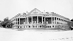
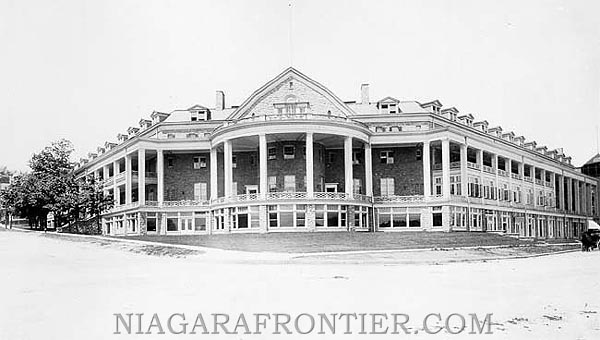
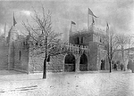
1932- This is the
second Clifton Hotel which was located at the corner of Ferry
Road (now Clifton Hill) and River Road. The picture is facing north-westerly.
Courtesy of John Guthrie
The site of the original Clifton Hotel remained untouched following its destruction by
fire until 1905 when the Clifton Hotel was rebuilt. This five storey structure was built
in a "U" shaped form at the corner of River Road and Clifton Hill facing the
American and Canadian Falls.
On December 31st 1932, the Clifton Hotel was once again destroyed by fire. The fire
started in the North wing and could not be controlled until most of the structure lay in
ruins.
Niagara Falls businessman, Mr. Harry Oakes purchased the site of the Clifton Hotel and the
Lafayette Hotel.
In 1933, Mr. Oakes traded this parcel of land (measuring 460 feet by 330 feet) to the
Niagara Parks Commission for a small tract of land just above the park. The property Oakes
traded for is today located along the south side of Clifton Hill.
Oakes Garden Theatre was built as an amphitheater by the design firm of Dunington,
Grubb & Stensson. The foundation walls of the old Clifton Hotel were included in the
construction design.
Construction on Oakes Garden Theatre began on October 1st 1935. It was officially opened
on September 18th 1937.
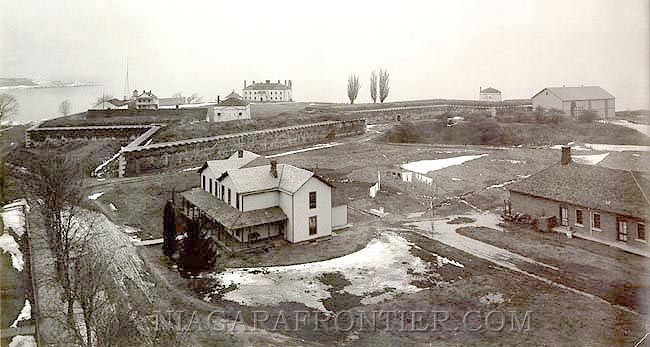
Fort Niagara
in Youngstown, New York
Courtesy of John Guthrie
The history of Fort Niagara
predates 1788 when the rest of the Niagara Frontier was for the most part not yet
developed.
On January 14th 1679, Henry de Tonti chose this site for a fortification. In two weeks a
log block house was built and was named Fort Conde.
Later in that year it was
destroyed by Indians. In 1686, Frenchman, Marquis de Denonville built a new fortification
at this site and called it Fort Denonville . It was abandoned in 1688.
In 1725, Chabert Joncair was
allowed by the Seneca Indians to build a Magazin Royal, a Cabin of Bark. In 1726, he built
a French castle or House of Peace overlooking Lake Ontario at present site of Fort
Niagara.
the Goat Island Bridge and the
north Goat Island Channel - 1890
Courtesy of John Guthrie
The picture is of the Goat Island Bridge looking north from Goat
Island to the American mainland via Bath Island (Green Island). When originally built by
Augustus Porter, the bridge was twelve feet wide and had a wooden deck.
This is the northern channel of water around Goat Island and is
the water channel which feed the American Falls.
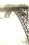
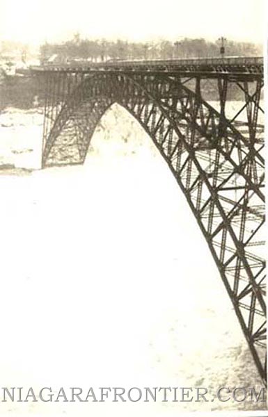
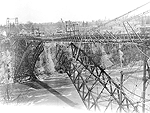
the Upper Steel Arch Bridge
(Honeymoon Bridge)
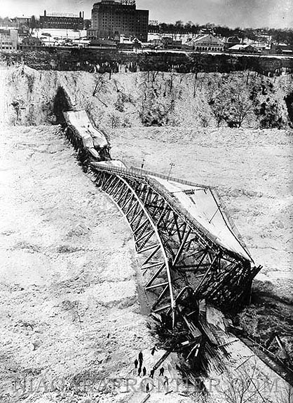
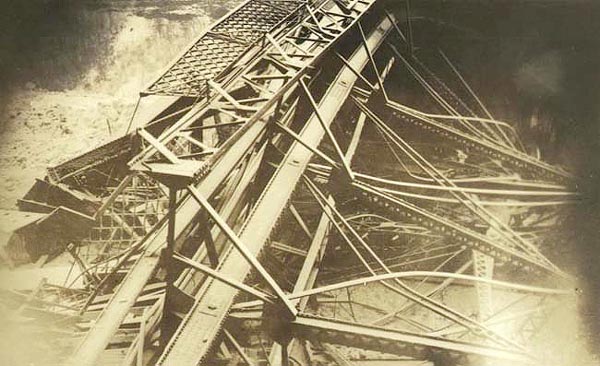
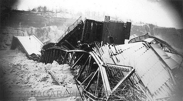
on January 27th 1938, just before its collapse
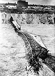
the Upper Steel Arch Bridge
(Honeymoon Bridge Collapse) - 1938
Courtesy of John Guthrie
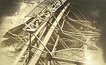
the Upper Steel Arch Bridge
(Honeymoon Bridge Collapse) - 1938

the Upper Steel Arch Bridge
(Honeymoon Bridge Collapse) - 1938
The first photograph is a picture of the Upper Steel Arch Bridge
on the same day just preceding its collapse on January 27th 1938.
The second, third and fourth photographs depict the remains of
the January 27th 1938 collapse of the Upper Steel Arch Bridge (aka: Honeymoon Bridge,
Falls View Bridge). One photograph was taken from the American shoreline and one was taken
from the Canadian shoreline and one from the river level.
The remnants of the bridge superstructure were blown apart with dynamite on February 5th
1938 in an attempt to sink them.

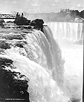
the American and Horseshoe
Falls - 1882
Courtesy of John Guthrie
This photograph of the unconstrained waters of Niagara Falls
before water diversion and remedial work. Notice the relative straight crest of the
American Falls comparing them to the crest line today.
The building on the American shore is the "Shadow of the Rock" incline railway
which serviced the Maid of the Mist Docks and a viewing platform for the American Falls
circa: 1880.
This picture would have been taken from the deck of the original Upper Suspension Bridge.
Two special observations, the Terrapin Tower at the crest of the Horseshoe Falls has been
torn down. It was built in 1833 and was a fixture for approximately 50 years. Obviously
torn down before 1882.
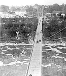
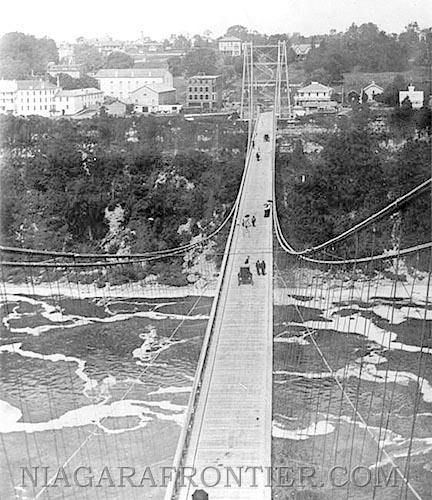
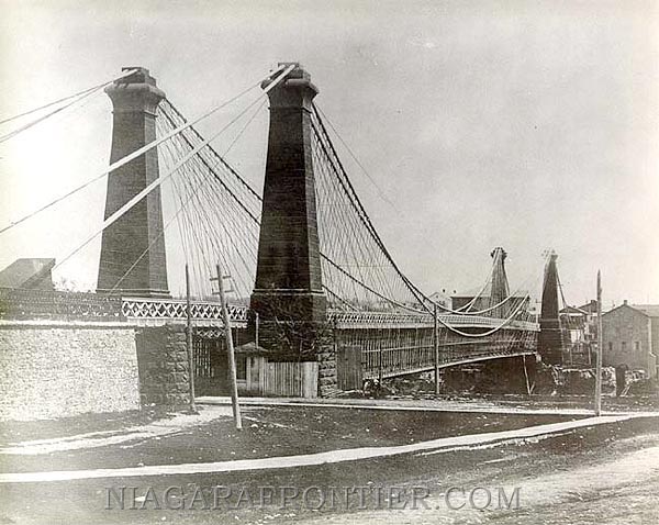
the Upper Suspension Bridge
circa: 1895
Courtesy of John Guthrie
A classic picture depicting the Upper Suspension Bridge circa:
1895, looking west to the Canadian shoreline from the American terminus. Still the days of
horse & buggy or walking.
This picture pre-dates 1896 because the building to the immediate left of the bridge
is the Lafayette Hotel which is still under construction. This hotel was not opened to the
public until 1896. Notice there are no windows yet installed in the hotel.
The original Upper Suspension Bridge dates back to 1869. It was destroyed on January 10th
1889 during a gale force wind storm. The wooden structure collapsed into the gorge.
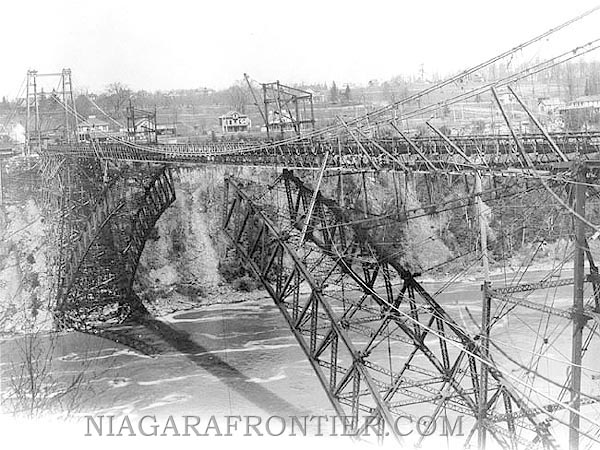
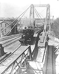
the Upper Suspension Bridge - 1897
Courtesy of John Guthrie
This is the Upper Suspension Bridge with the steel arch
superstructure being built underneath the wooden structure. Construction began on the
steel arch on or about May 27th 1897 and was open to traffic on June 23rd 1897.
Picture taken from the American shore looking westward into Canada.
The Upper Suspension Bridge was dismantled and then re-erected at Queenston -
Lewiston to become the second suspension bridge at that site.
The steel arch bridge became known as the Upper Steel Arch Bridge (aka: Honeymoon Bridge,
Falls View Bridge). It was this Honeymoon Bridge that collapsed in 1938.
the third Railway Suspension Bridge -circa 1881
Courtesy of John Guthrie
This picture is taken from the American shore looking west into
Canada (the Town of Niagara Falls - 1881). It is the third Railway Suspension Bridge (now
aka: the Lower Arch Bridge, the Whirlpool Bridge) located at the foot of bridge Street.
The picture can be dated after 1885 because the new Customs and Post Office building can
be seen at the corner of then Clifton and Park St (it wasn't opened until 1885). Its the
large pitched roof building just to the left of the bridge tower.
More and more demands were being placed onto the existing Railway
Suspension Bridge that was completed in 1855. Trains crossed more frequently and became
larger and their loads heavier. Soon the stresses placed upon the existing bridge
structure were becoming too great and safety became a big concern.
The work of renovating the Railway Suspension Bridge was carried out by Leffert L. Buck,
an American engineer who later went on to become famous for his design of great steel arch
bridge which eventually replaced the suspension bridge.
The beauty of the second bridge was sacrificed for one of much greater strength.
Increasing trade and commerce demanded that wood and stone be replaced with steel. Slender
steel pylons replaced the thick stone towers. Steel beams and trusses replaced the wooden
frame work.
The entire renovation was completed by 1886. No accidents occurred during construction and
with little interruption to rail traffic.
This new structure was capable of carrying an increased load from 300 tons to 350 tons
which was much more than any train and load was capable of weighing. All that remained of
the second bridge was the anchorage's and cables but they too had been overhauled and
improved.
This bridge continued in service for ten years, when pressure from the railway company and
the economy began calling for the design and building of a more modern steel arch type
bridge.
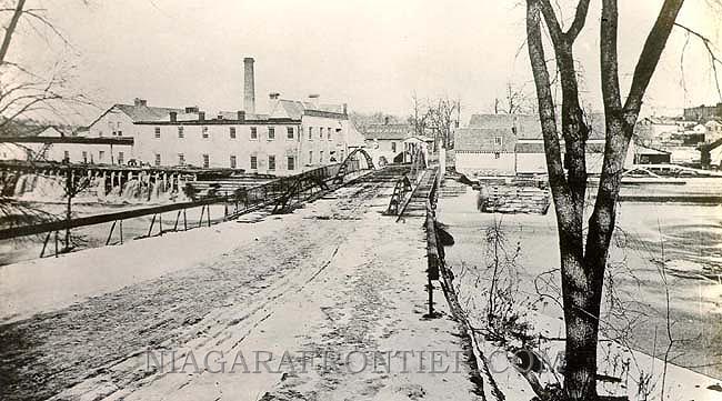
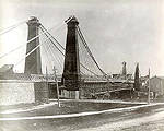
The Bath Island Paper Mill -
circa 1823 - 1885
Courtesy of John Guthrie
This is a rare picture of The Bath Island Paper Mill which was
built on Bath Island (now Green Island) located in the Upper Rapids between Goat Island
(then known as Iris Island) and the American mainland. The mill was built in 1823 and
continued in operation until the creation of the Reservation State Park in 1885.
Prior to the expropriation of land by the State of New York for the Reservation State
Park, the shoreline of the American mainland upstream of the Falls and Green Island were
industrialized. The paper mill was one of these factories.
The bridge in the picture is the Goat Island Bridge which is the shorter of the two spans
(from Goat Island to Baths Island). The Goat Island Bridge continues from Bath Island to
the American mainland.
The first Railway Bridge - 1875
Courtesy of John Guthrie
The first Railway Bridge circa:1855. This bridge remained in
place until 1880 when the wooden superstructure was replaced with an iron superstructure.
It was located at the present site of the Whirlpool Bridge (aka: Lower Bridge, Whirlpool
Rapids Bridge) located at the foot of Bridge Street at River Road.
This photograph is looking eastward towards the American shoreline from the Canadian
terminus.
In 1853, bridge designer/engineer John A. Roebling came to Niagara. Roebling was the
person responsible for the building of the Railway Suspension Bridge to allow the Grand
Trunk Railway to connect from Canada to the USA .
Prior to this undertaking, Roebling had built one smaller suspension bridge and five
aqueducts. Roebling's plan for a suspension bridge for trains across the Niagara Gorge met
with much opposition. Most thought that a suspension bridge would not be capable of
standing up to the weight and stresses of a locomotive and other rail cars. Roebling was
of the belief that no other type of bridge was suitable for the Niagara Gorge and that the
suspension bridge was the future for long span bridges.
In 1851, with a need for a train bridge across the Niagara Gorge, rthe
Bridge Company selected Roebling's original bridge design over those submitting by Samuel
Keefer and Edward W. Serrell.
The second bridge had two stone pylons at each end to support the four large iron cables.
The railway deck was built above the carriage floor and both were joined by a latticed
truss of wood construction forming what appeared to be a long narrow cage across the
gorge. A large number of guy wires from the bridge to the cliff wall were utilized to
counteract the effects of the wind.
Two men died on October 10th 1854 during the bridge construction when a scaffold holding
four men collapsed.
On March 8th 1855, the first locomotive named "London" crossed the bridge. It
was one of the largest engines of its time, weighing twenty-three (23) tons. It crossed at
a speed of eight (8) miles per hour (mph) and caused a deflection of only three and one
half inches at the center of the span.
The bridge cost four hundred and fifty thousand dollars ($450,000) and became one of the
worlds most famous. Over a period of twenty-five (25) years, an average of fifty trains a
week crossed this bridge.
John A. Roebling later became famous in his bridge designs with his building of the
Brooklyn Bridge in New York City. Roebling died during its construction and never saw its
completion.
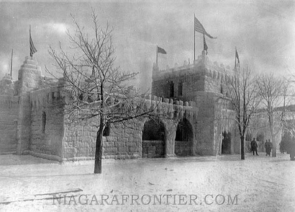
the Ice Palace - circa: 1899
Courtesy of John Guthrie
This is a picture of the ice palace that
was built during the 1898-1899 American Winter Festival held at Niagara Falls
New York. It was built during an ice sculpture contest.
The "Great Ice Palace" was built
on the Riverway overlooking the American Falls and the Niagara Gorge. The palace
was 120 feet (36.5m) wide by 160 feet (48.7m) long and was built entirely of
large blocks of ice. The walls were up to 7 feet (2.1m) thick and had three ice
towers built in. A 90 feet (27.4m) by 160 feet (48.7m) skating rink adorned the
outside of the palace. An entrance fee was charged to enter the palace and at
night it was illuminated by colorful lights. The "Ice Palace" project
was financed by a group of prominent citizens.
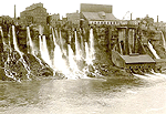
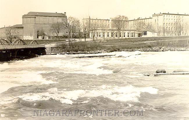
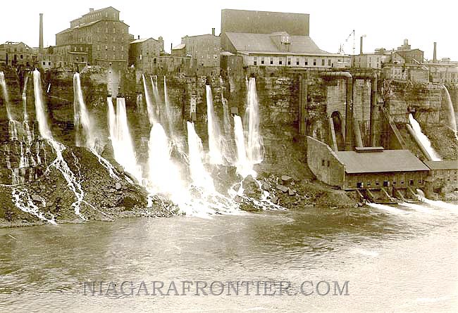
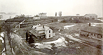
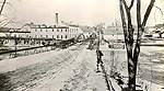
the mill district of Niagara Falls, New York
circa: 1890's
Courtesy of John Guthrie
Niagara mills drew water from the Upper Rapids and not from the
Falls. Industries continued to use water-wheels until the turbine was developed.
The only large scale development of Niagara Falls power
milling district of the Niagara Falls Hydraulic Power and Manufacturing Company located in
Niagara Falls, New York.
The Niagara Falls Hydraulic Power and Manufacturing Company was
chartered in 1853.
The Niagara Falls Hydraulic Power and Manufacturing Company under
the direction of Horace D. Day built an open canal extending 4,400 feet long from the
Upper Niagara River at Port Day leading to the mill district located downstream from the
falls.
This canal was 35 feet wide and 8 feet deep. It carried water to
a reservoir located just to the east of the mills. The industries tapped into the water
reservoir and with a head of water only 25 - 75 feet, channeled water into their
respective mills where water-wheels generated the power to drive the machinery.
Most of the machinery utilized large belts to transmit the power
from the water-wheel to the machinery. Water was then channeled by short tunnels bored
into the rock of the gorge water to allow its discharge into the river below.
This discharge was known as the "tailrace". Quite often
the tailrace fell into the gorge from a considerable height. The tailrace discharge of the
many industries became quite a tourist attraction in their own right second only to the
Falls of Niagara.
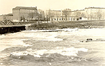
Niagara Falls
circa: 1833 - 1887
Courtesy of John Guthrie
The platform the men are standing on at the brink of the Horseshoe Falls was an extension
of the boardwalk that led from Terrapin Point on Goat Island leading to Terrapin Tower
(just out of site).
Notice the the mill and shanty at the Table Rock. The large building on the hill is what
was to become Oak Hall and at that time was owned by Samuel Street who operated a mill at
the rivers edge opposite Dufferin Islands.

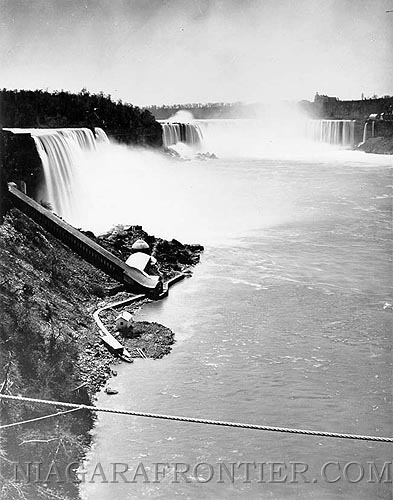
The unusually heavy ice
conditions at the dock of the Maid of the Mist - January 1938.
These same ice conditions were responsible for the collapse of the Upper Steel Arch
Bridge (Honeymoon Bridge Collapse) on January 27th 1938
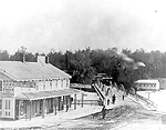
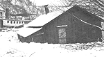
the Tugby and Walker Variety
Store, circa: 1870's-1880's. The variety store was located on the main land of Manchester
(Niagara Falls, New York) beside the Goat Island Bridge leading to Bath Island. The small
white house on Bath Island is a bath house for which the island was named.
courtesy of John Guthrie
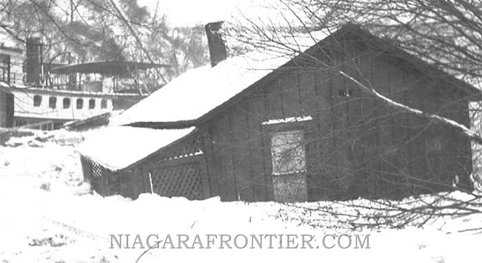
The Maid of the Mist Cabin
located on the Canadian shoreline was destroyed by ice in January 1938. The ice jam of
January 1938 was the worst on record and resulted in a tremendous amount of damage
including the collapse of the Honeymoon Bridge.
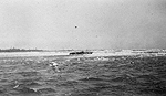
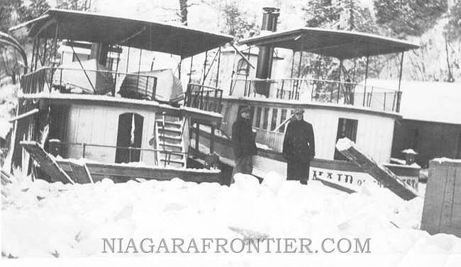
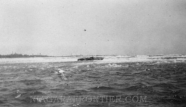
June 1923 - A view
of the remains of the Subchaser - "Sunbeam" in the Niagara River just upstream
of the Horseshoe Falls
|
NIAGARA
FALLS THUNDER ALLEY NAVIGATOR |
|
|
|
|
SITE MAP |
Date last updated:
February 13, 2012
THANK YOU FOR VISITING
the
NIAGARA
FALLS
HISTORICAL PHOTOGRAPH
COLLECTION PAGE #1
PAGE
|