The Plan The 1830’s City of the Falls project was to establish a large residential city at the Falls sponsored by some of the most prominent and influential citizens upon lands known as Falls View. In 1832, James Buchanan wrote a letter to the Honourable Thomas Clark stating that he had seen an advertisement that William Forsyth wished to dispose of his establishments and lands at the Falls. Buchanan suggested Clark and Samuel Street buy out Forsyth and outlined his plans in his letter for the development for this land. This plan would become the basis upon which the “City of the Falls” project was born. The promoters of the City of the Falls project had two goals:
For many years and until the 1940’s, Falls View was commonly known and referred to as the City of the Falls. The name Falls View was derived from the fact that trains of the Michigan Central Railroad (Canadian Southern Railroad) had been stopping their trains at this area since 1885 in order to give their passengers a few minutes to view the Falls. The area was located at the top of the moraine, which provided an unobstructed panoramic view of the Falls. This was a popular viewing are for many generations. In the mid to late 1700’s this area was known on maps as “Grand View”.
Company Officials In 1832, the City of the Falls Company was formed by a number of prominent citizens. They included: James Buchanan, His Majesty’s Counsel at New York who at the time of his retirement made his home in Drummondville. (2 shares) Honourable William Allan, President of the Bank of Upper Canada (1 share) Honourable John Henry Dunn, Receiver General of Upper Canada (1 share) Thomas Dixon, President of the Society of St. George of New York (1 share) Lieutenant General John Murray, a retired officer of the British Army (3 shares) James Robinson, Resident Agent of the City of the Falls Company (1 share) Samuel Street Jr., partners in the firm Clark & Street (1.5 shares) Thomas Clark, partners in the firm Clark & Street (1.5 shares)
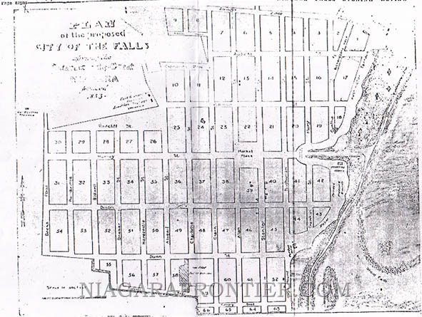
The City of the Falls Plan The newly formed City of the Falls Company purchased 400 acres of land from William Forsyth. They began laying out their city in streets and lots. The Company had subdivided the new city into approximately 300 – 400 lots worth $400 per lot. Each average lot boasted a frontage of up to 35 feet by 140 feet deep. Lots bordering the river had frontages averaging 50 feet with the occasional lot being 100 feet wide. The high bank had a carriage road laid out along the ridge measuring 50 feet wide. A space measuring 100 – 200 feet was set aside for gardening and walks, which offered one of the most sublime promenades in the world looking down upon the great Falls of Niagara. Every person buying a lot would also be awarded one share in the City of the Falls Company. In addition, the City of Falls Company sold 2600 shares at $100 each. Stanley Street was 100 feet wide. All other streets were 80 feet wide. Stable Lanes were 20 feet wide. The plan of 1833, surveyed by E. Clements was not registered but another sub-division plan of the City of the Falls was registered at the Fonthill registry office in 1851. About half of the streets of the 1833 plan, the market square and the terraces were eliminated in the 1851 registered plan but the street names of the promoters remained. Cedar Island is called Long Island, although the registry office called it Swayze Island because it was once leased by Isaac Swayze. The original plan was to have a market square at the intersection of Murray Street and Allen Street. The City of the Falls plan boasted some of the widest streets in the city. The 1851 plan showed a tollgate at the corner of Portage Road and Dunn Street. The company paid full costs of local improvements. A water works system was installed using wooden pipes to transport the water. The water pressure proved to be too great for the wooden structures causing the pipes to burst apart. The company had built their own water works system included a pumping station at Table Rock (at the edge of the Horseshoe Falls). It would be capable of producing 80 gallons of water per minute. The station was operated by a water wheel with a sluice and a water dam. A water tower was built on the high ground at the top of the moraine. This tower was also used for a short time as an observation tower. Wooden pipes were laid to this water tower and from there to all the company houses and hotels including the new Bath House. Unfortunately, when the pumps were started to pump the water through the wooden water pipes, the pressure was too great for the wooden pipes causing them to burst.
Many of the streets in the new survey were named after the charter members of the City of the Falls Company. Stanley Street was given its name by the City of the Falls promoters. There was no shareholder by that name but it was probably named in honour of the Honourable E.G. Stanley, then Colonial Secretary in the British Government. Other street names included Hay’s Mount, Royal Terrace, and Point Turnagain. In Stamford Township, Victoria Avenue was known as the 1st Concession, Stanley Street was the 2nd Concession, Drummond Road was the 3rd Concession and Dorchester Road was the 4th Concession. The original plans include schools, churches, libraries, ball & promenade rooms and public gardens. Three prominent hotels already stood within the boundaries of the new City of the Falls. They included: The Pavilion House stood on the top of the moraine just south of the entrance to Oakes Drive (Fallsview Boulevard). The Pavilion House was the largest hotel in the area. The Ontario House which was located on the west side of Portage Road just north of Loretto Academy. This became the headquarters for the City of the Falls Company. The Red House (Prospect Hotel) was located on Portage Road near Lundy’s Lane.
The Bath House The City of the Falls Company built a new magnificent hotel as a health resort and tourist center. This would become known as the famous Bath House. It built on the south side of Murray Hill near the current boundary of Queen Victoria Park. This was a large three storey frame structure and was grandiose in size and style. The main corridors of this hotel stood higher than the top of the adjacent moraine and ran through the center of the building in the formation of a cross. The mammoth bathtubs were located in the basement rooms with provisions for plenty of hot water. After the failure of the City of the Falls project, the Bath House was put to other uses. First it became a hotel and then a girl’s boarding school. There is a report that at one time servants slept in the huge straw filled bathtubs of the Bath House. During the 1837–1838 Rebellion, it was used as a barracks with accommodation for 113 non commissioned officers and soldiers. During the military occupation, the government paid an annual rental fee. The military built a strong black hole in the basement of the former Bath House for the confinement of insubordinate soldiers of which one committed suicide while confined in the hole by shooting himself in the head. The bath house was later destroyed by fire.
The Failure of the City of the Falls Project The promoters were also betting on the amount of visitors to Niagara Falls visiting from Buffalo by train. All the train traffic had to follow the Canadian route because there was no steam railroads yet built on the American side. The Chippawa & Queenston Railway (Erie & Ontario Railroad) provided a direct link from lake Erie to lake Ontario. The City of the Falls was very slow to grow and only a few of the lots were sold and fewer homes were built. In 1836, steam railroads were completed on the American side. This diverted the much-anticipated traffic that the promoters of the new city were counting on. This proved to be a deathblow to the City of the Falls plan from which there was no recovery. The entire proposed enterprise had become too costly. The Company expected to make a profit and this simply did not occur. Eventually the City of the Falls Company ran out of money.
Biographies
Honourable William Allan (Allan Street) Allan Street derived its name from the Honourable William Allan. The part of Allan Street was covered in thick bush near Ferry Street until 1892. Allan was later changed by mistake to Allen. A portion of Allan Street was an unopened road allowance between Murray Street and Dixon Street until 1929. William Allan was born in 1770 in Aberdeenshire in Scotland. He came to Montreal in 1787 where he was employed as a junior clerk. Eight years later he moved to York (Toronto) and opened a general store. Allan became a customs officer and later became postmaster of York and a Justice of the Peace. In the War of 1812, Allan was a major and a Colonel of the York Regiment. In 1825, Allan was appointed to the Legislative Council of Upper Canada and eleven years later to the Executive Council. It is said that Allenburg was named by Allan’s participation in the development of the Welland Canal. William Allan died in 1853.
Honourable John Henry Dunn (Dunn Street) Dunn Street was 80 feet wide and was originally opened fro Drummond Road to the Niagara River. That portion of Dunn Street east of Portage Road was closed in 1885 when the Canadian Southern Railroad was built. Dunn Street was named after the Honourable John H. Dunn, the Receiver General of Upper Canada. As Receiver General, he was required to provide security. Two of the bondsmen were local men: Honourable Thomas Clark for 10,000 £ and Samuel Street for 5,000 £. John Dunn was one of the original directors of the Welland Canal Company. In May 1824, Dunn was chosen the 1st President of the Welland Canal Company but he declined. George Keefer of Thorold became the 1st president while Dunn became the 2nd president the next year. The Township of Dunnville and the Town of Dunnville were named for John H. Dunn.
James Robinson (Robinson Street) Robinson Street runs from Main Street to the Niagara River. The eastern portion of Robinson Street an unopened road allowance has never been opened to vehicular traffic. Only a footpath exists to this day. This footpath is known as the “Jolly Cut”. Legend has it years ago, a young English guest staying at the Brunswick Hotel located at the base of the moraine near this path was shown by others this short route via Robinson Street to get to Main Street in Drummondville. Upon the Englishman’s return to the hotel, he is said to have exclaimed, “What a jolly cut”. Ever since this path has been known as the Jolly Cut. Robinson Street was named after John Robinson. Robinson was a shareholder and the superintendent of the City of the Falls Company. He later became a magistrate.
James Buchanan (Buchanan Street) Buchanan Street ran from Ferry Street to Portage Road. It was named after James Buchanan, a shareholder of the City of the Falls Company. Buchanan was a British Counsel at New York from 1816 to 1843. Following his retirement, he settled in Niagara. In 1846, James Buchanan was one of the Canadian Commissioners of the first Niagara Falls Suspension Bridge Company. In April of 1851, shortly before his death, Buchanan purchased the historic Forsyth home on Main Street (Bunker Hill) in Drummondville.
Thomas Clark (Clark Street) Clark Street runs from Ferry Street to Robinson Street. It was named after the Honourable Thomas Clark. He was of Scottish decent and lived in a mansion on Clark Hill (Oaks Hall) overlooking Dufferin Islands. Thomas Clark and Samuel Street Jr. were business partners, merchants and mill owners. They were two of the wealthiest men in Upper Canada. Together, they were the primary movers in the development of the City of the Falls project. Thomas Clark became a member of the Legislative Council of Upper Canada In 1827, Clark & Street built the road to the Maid of the Mist dock. Thomas Clark died in 1837. He was 67 years old.
Thomas Dixon (Dixon Street) Dixon Street ran from Drummond Road to the Niagara River. The eastern portion of Dixon Street was closed as a result of Canadian Southern Railroad. It was named after Thomas Dixon, the President of the Society of St. George of New York. Dixon was one of the only non-resident shareholders of the City of the Falls Company.
John Murray, Lieutenant General (Murray Street) Murray Street ran from Drummond Road to the Niagara River. It was named after Lieutenant General John Murray of the British Army was the Governor of Demerara, British Guiana. He had a business in a West Indian sugar plantation in the early days when slavery was still tolerated. In 1833, when slavery was abolished within the British Empire, for compensation for the loss of his enslaved workforce Murray received 100,000 pounds sterling from the government. Upon his retirement, John Murray lived for a short time in Monroe, Michigan. He then settled in Drummondville where he lived on Main Street facing Robinson Street. He became one of the promoters of the City of the Falls project where Murray held 19 large building lots. He also became a part owner of the Pavilion Hotel, the first hotel in the area. In 1837, Lieutenant General Murray left Canada and moved to Europe in order to educate his children. He never returned to Niagara. Murray died in Paris, France on September 16th 1841. Following Murray’s death, his wife Ellen and his children returned to Drummondville.
Today, there is nothing left of the "City of the Falls" project except for the historic names of the streets, which were named to commemorate those persons who comprised the City of the Falls Company.
Date last updated: February 12, 2012
THANK YOU FOR VISITING
a
history
|
||||||||||